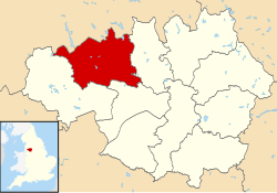
The Metropolitan Borough of Bolton is a metropolitan borough of Greater Manchester, England.
It is named after its largest settlement,
Bolton, but covers a far larger area which includes
Blackrod,
Farnworth,
Horwich,
Sharples,
Kearsley and
Westhoughton,
and a suburban and rural element from the West Pennine Moors.
The borough has a population of 276,800, and is administered from Bolton Town Hall.
The boundaries the Bolton metropolitan district were set as part of the provisions of the Local Government Act 1972, and cover an amalgamation of eight former local government districts; seven Urban Districts from the administrative county of Lancashire, and the
County Borough of Bolton.
The metropolitan districts of Bury, Salford and Wigan lie to the east, south and west respectively; and the non-metropolitan districts of Blackburn with Darwen and Chorley in Lancashire lie to the north and north-west.
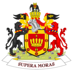
The Arms of Bolton Metropolitan Borough Council are a pun on the word Bolton, as they depict an arrow (a "bolt") passing through a crown (a "tun").
History
The metropolitan borough was formed on 1 April 1974, by the merger of the
County Borough of Bolton
and the following districts from the administrative county of Lancashire:
- The Municipal Borough of Farnworth
- The Urban district of Horwich
- The Urban district of Westhoughton
- The Urban district of Blackrod
- The Urban district of Kearsley
- The Urban district of Little Lever
- The southern part of the Urban district of Turton, specifically the villages of
Bradshaw,
Bromley Cross, Dunscar,
Egerton and
Harwood. This area is now known as
South Turton.
Bolton Council unsuccessfully petitioned Elizabeth II for the Metropolitan Borough of Bolton to be granted city status in 1992 (the Queen’s 40th year as monarch), in 2000 (for the Millennium celebrations), in 2002 (Queen’s Golden Jubilee), and 2012 (Queen's Diamond Jubilee).
Parishes
Horwich,
Westhoughton and
Blackrod
are now constituted as civil parishes.
There are three town councils in the metropolitan borough, Westhoughton Town Council, Horwich Town Council and Blackrod Town Council.
The rest of the metropolitan borough,
Bolton,
Farnworth,
Kearsley,
Little Lever, and
South Turton,
have remained unparished areas since 1974.
Demographics
According to the 2009 estimates, of the 265,100 people living in Bolton Metropolitan Borough, the following ethnicities have been recorded:
- 88.0% White
- 85.9% White British
- 1.2% Other White
- 0.8% White Irish
- 9.3% South Asian
- 5.9% Indian
- 2.7% Pakistani
- 0.5% Other South Asian
- 0.2% Bangladeshi
- 1.2% Mixed Race
- 0.5% White and Asian
- 0.4% White and Black Caribbean
- 0.2% White and Black African
- 0.2% Other Mixed
- 1.0% Black
- 0.6% Black African
- 0.4% Black Caribbean
- 0.1% Other Black
Population change
The table below details the population change since 1801, including the percentage change since the last available census data.
Although the Metropolitan Borough of Bolton has only existed since 1974, figures have been generated by combining data from the towns, villages, and civil parishes that would later be constituent parts of the borough.
| Population growth in Bolton since 1801 |
| Year |
Population |
% change |
|
Year |
Population |
% change |
|
Year |
Population |
% change |
| 1801 |
37,417 |
– |
|
1871 |
158,917 |
+20.0 |
|
1941 |
256,207 |
−1.9 |
| 1811 |
48,996 |
+30.9 |
1881 |
185,397 |
+16.7 |
1951 |
251,388 |
−1.9 |
| 1821 |
60,319 |
+23.1 |
1891 |
216,792 |
+16.9 |
1961 |
255,627 |
+1.7 |
| 1831 |
75,787 |
+25.6 |
1901 |
240,014 |
+10.7 |
1971 |
259,993 |
+1.7 |
| 1841 |
89,507 |
+18.1 |
1911 |
265,733 |
+10.7 |
1981 |
260,229 |
+0.1 |
| 1851 |
105,957 |
+18.4 |
1921 |
263,413 |
−0.9 |
1991 |
262,880 |
+1.0 |
| 1861 |
132,437 |
+25.0 |
1931 |
261,119 |
−0.9 |
2001 |
261,035 |
−0.7 |
| Source: Vision of Britain |
Transport
The Bolton metropolitan area is served by the following railway stations:
Education
In 2007, Bolton was ranked 69th out of the 149 Local Education Authorities — and sixth out of ten in Greater Manchester — for its National Curriculum assessment performance.
Measured on the percentage of pupils attaining at least 5 A*–C grades at GCSE including maths and English, the Bolton LEA was 111th out of 149: 40.1% of pupils achieved this objective, against a national average of 46.7%.
Unauthorised absence from Bolton's secondary schools in the 2006/2007 academic year was 1.4%, in line with the national average, and authorised absence was 6.0% against the national average of 6.4%.
At GCSE level, Bolton School (Girls' Division) was the most successful of Bolton's 21 secondary schools, with 99% of pupils achieving at least 5 A*–C grades at including maths and English.
The University of Bolton is one of Greater Manchester's four universities. In 2008, The Times Good University Guide ranked it 111th of 113 institutions in Britain.
There are 4,440 students (83% undergraduate, 17% postgraduate); 2.6% come from outside Britain.
In 2007 there were 8.8 applications for every place, and student satisfaction was recorded as 74.4%.
It is one of Britain's newest universities, having been given this status in 2005.
GCSE Examination Performance 2009
| School |
A*-C
Pass Rate |
Point
Score |
| Bolton Muslim Girls' School |
100% |
533.1 |
| Bolton School (Girls' Division) |
98% |
546.7 |
| Canon Slade C of E School |
93% |
508.5 |
| Lord's Independent School |
93% |
401.5 |
| St Joseph's RC High School and Sports College |
85% |
426.6 |
| Madrasatul Imam Muhammed Zakariya |
79% |
347.3 |
| Al Jamiah Al Islamiyyah at Mount St Joseph's Convent |
79% |
327.9 |
| Ladybridge High School |
78% |
437.6 |
| Turton School |
76% |
396.1 |
| Sharples School |
74% |
414.1 |
| Westhoughton High School |
67% |
424.0 |
| Rivington and Blackrod High School |
69% |
456.7 |
| Essa Academy |
67% |
383.7 |
| Smithills School |
66% |
400.8 |
| Little Lever Specialist Language College |
61% |
442.7 |
| Mount St Joseph Business and Enterprise College |
61% |
422.7 |
| Harper Green School |
59% |
384.7 |
| George Tomlinson School |
55% |
307.4 |
| Bolton School (Boys' Division) |
52% |
240.4 |
| Average for Metropolitan Borough of Bolton |
71.4% |
422.5 |
| Average for England |
70.0% |
413.5 |
- The table on the left shows the percentage of students gaining five A* to C grades, including English and Maths, for secondary schools in the Metropolitan Borough of Bolton.
- The table on the right shows the Average Total Point Score per Student for secondary schools in the Metropolitan Borough of Bolton.
- Schools highlighted in yellow are above the LEA average; those highlighted in orange are below the average.
- Another secondary school, Bolton Muslim Girls' School, has opened since January 2007; no results are available.